 EMODnet Product Catalogue
Swedish Agency for Marine and Water Management
Type of resources
Available actions
Topics
Keywords
Contact for the resource
Provided by
Years
Formats
Scale 1:
Resolution
-
Data collected within various monitoring programmes and surveys. Standard zoobenthos techniques using benthic grabbers and species analyses for counts and weights on species level.
-
The national monitoring program was initiated by the Swedish Environmental Protection Agency and is now financed by the Swedish Agency for Marine and Water Management. Monitoring is performed by Stockholm University, Umeå University, Swedish Meteorological and Hydrological Institute and Gothenburg University. Data are stored in the Swedish Ocean Archive (SHARK) by the Swedish Meteorological and Hydrological Institute (SMHI).
-
Data collected within various monitoring programmes and surveys. Standard quantitative phytoplankton techniques following HELCOM MONAS guidelines. Counts and sometimes biovolumes on species level.
-
The national monitoring program was initiated by the Swedish Environmental Protection Agency and is now financed by the Swedish Agency for Marine and Water Management. The monitoring is performed by the Swedish Museum of Natural History. Data is stored in the database SHARK, hosted and maintained by the Swedish Meteorological and Hydrological Institute. Monitoring of seals is performed by counting seals from land, ship or airplane. More information is available in Swedish at https://www.havochvatten.se/hav/samordning--fakta/miljoovervakning/miljoovervakningens-programomrade-kust-och-hav/delprogram-sal-och-havsorn.html
-
Bacterial cell carbon content, cell volume and concentration at various sampling stations in the Swedish part of the Baltic Sea. Sampling is performed with a rosette sampler or Niskin bottles attached to a wire. Bacterioplankton has been monitored in Sweden since 1989. The national monitoring program was initiated by the Swedish Environmental Protection Agency and is now financed by the Swedish Agency for Marine and Water Management. Monitoring is performed by Umeå University. Data is stored in the Swedish Ocean Data Archive (SHARK) database by the Swedish Meteorological and Hydrological Institute.
-
Data from Swedish environmental monitoring of abundance of Ringed seal. Swedish monitoring of Ringed seals started in 1995. The monitoring program was initiated by the Swedish Environmental Protection Agency and later the Swedish Agency for Marine and Water Management took over the responsibility and financing of the program. The monitoring is performed by the Swedish Museum of Natural History. Data is stored in the database SHARK, hosted and maintained by the Swedish Meteorological and Hydrological Institute. Monitoring of ringed seal is performed by counting seals in transects from airplane. More information is available in Swedish at https://www.havochvatten.se/hav/samordning--fakta/miljoovervakning/miljoovervakningens-programomrade-kust-och-hav/delprogram-sal-och-havsorn.html
-
Epibenthos has been nationally monitored in Sweden since 1992. The monitoring program was initiated by the Swedish Environmental Protection Agency and later the Swedish Agency for Marine and Water Management took over the responsibility and financing of the program. The monitoring is performed by Stockholm University, University of Gothenburg and Linnaeus University. The data is stored in the database SHARK, hosted and maintained by the Swedish Meteorological and Hydrological Institute. The epibenthos monitoring program studies hard and soft bottoms from the surface down to 10-20 meters. Data is collected in transects or squares with help of divers. Species abundances are determined directly by the divers or photographs are taken and analyzed later. More information is available in Swedish at https://www.havochvatten.se/hav/samordning--fakta/miljoovervakning/miljoovervakningens-programomrade-kust-och-hav/delprogram-vegetationskladda-bottnar.html
-
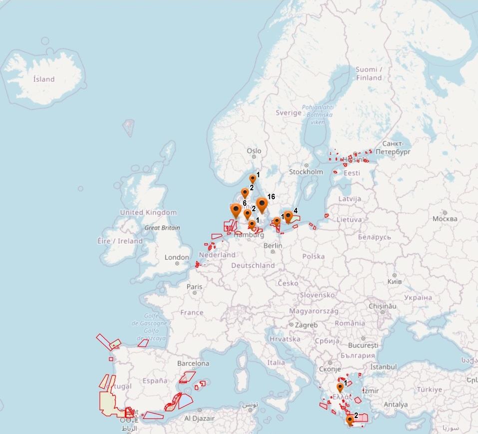
The dataset on offshore military areas in the European seas was created in 2020 by CETMAR for the European Marine Observation and Data Network (EMODnet). It is the result of the aggregation and harmonization of datasets provided by several sources. It is updated every year and is available for viewing and download on EMODnet web portal (Human Activities, https://emodnet.ec.europa.eu/en/human-activities). The dataset contains points and/or (where available) polygons representing offshore military areas in the following countries: Belgium, Bulgaria, Denmark, Estonia, Finland, Germany, Greece, Ireland, Latvia, Lithuania, Netherlands, Poland, Portugal, Spain and Sweden. Each point and/or polygon has the following attributes (where available): Country, Country_2, Country_3, Status (Active, Deactivated, Unknown, Planned), Type_1 (Firing Area, Air Force Exercise, Surface Exercise, Underwater Exercise, Mine Hunting Exercise, National Defence Area), Type_2, Type_3, Resource, Distance to coast (metres) and Area (square kilometres). The distance to coast (EEA coastline shapefile) has been calculated using the UTM WGS84 Zone projected coordinate system where data fall in.
-
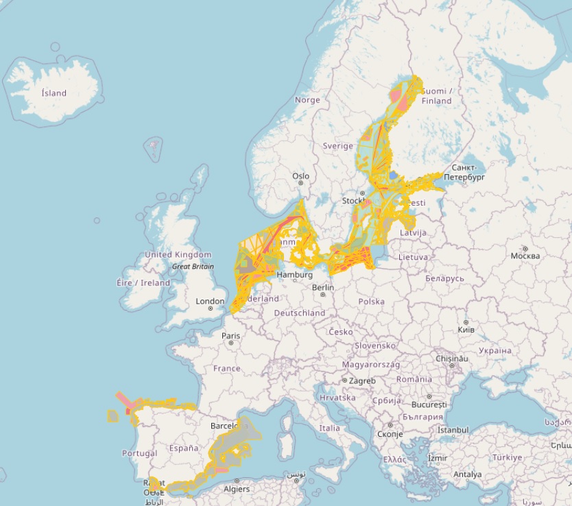
The database on Maritime Spatial Planning (MSP) in the EU was created in 2021 by CETMAR for the European Marine Observation and Data Network (EMODnet). It is the result of the aggregation and harmonization of datasets provided by several sources. It is updated as soon a new plan is adopted by an EU member state and it is available for viewing and download on EMODnet web portal (Human Activities, https://emodnet.ec.europa.eu/en/human-activities). The database contains polygons, points and lines (where available) representing Maritime Spatial Planning (MSP) in the following countries: Belgium, Denmark, Estonia, Finland, Germany, Latvia, Netherlands, Poland, Spain and Sweden. Maritime Spatial Planning (MSP) database is made up of 3 types of spatial features: MSP Spatial Plan, MSP Zoning Element and MSP Supplementary Regulation. Also there is a non spatial feature called MSP Official Documentation. The distance to coast (EEA coastline shapefile) has been calculated using the UTM WGS84 Zone projected coordinate system where data fall in.
-
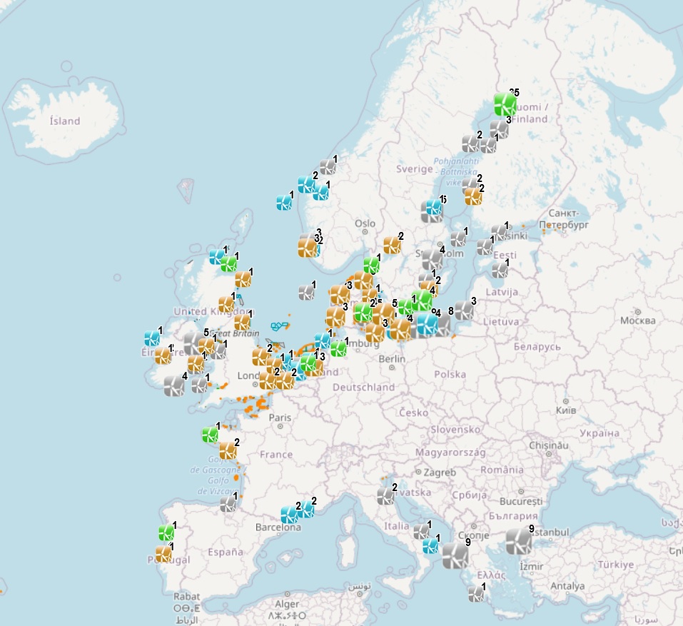
The dataset on offshore wind farms in the European seas was created in 2014 by CETMAR for the European Marine Observation and Data Network (EMODnet). It is the result of the aggregation and harmonization of datasets provided by several sources. It is updated every year and it is available for viewing and download on EMODnet web portal (Human Activities, https://emodnet.ec.europa.eu/en/human-activities). The dataset contains points and/or (where available) polygons representing offshore wind farms in the following countries: Belgium, Denmark, Estonia, Finland, France, Germany, Greece, Ireland, Italy, Latvia, Lithuania, Netherlands, Norway, Poland, Portugal, Spain, Sweden and United Kingdom. Each point and polygon has the following attributes (where available): Name, Nº of turbines, Status (Approved, Planned, Dismantled, Construction, Production, Test site), Country, Year, Power (MW), Distance to coast (metres) and Area (square kilometres). The distance to coast (EEA coastline shapefile) has been calculated using the UTM WGS84 Zone projected coordinate system where data fall in.